Oklahoma Social Studies 4.C.2
Standard Cluster
Apply the tools and concepts of geography to examine the physical and human geography of the United States of America. Use geographic tools to acquire and process information from a spatial perspective. Use and describe various elements of maps (e.g., key/legend, scale, cardinal and intermediate directions) to examine the physical and human features of the nation. Use maps and other geographic representations (e.g., globes, charts, graphs) and geographic technologies to draw conclusions (e.g., settlement patterns, population trends, population density, relative location of natural resources to manufacturing centers). Use the system of latitude and longitude to identify the absolute location of physical and human features of the United States of America. Interpret aerial photographs, satellite images, and thematic maps to locate and identify physical and human features of the United States of America and North America. Analyze the human and physical characteristics of the United States of America using the Five Themes of Geography (location, place, human-environment-interaction, movement, region) as a strategy to organize and compare each major region of the United States of America. Identify major physical regions of the United States of America and their unique features. Identify the location and the physical characteristics of the major landforms and bodies of water in the United States of America. Describe the location of major climate zones (tropical, temperate, continental, polar) explaining how climate affects natural vegetation. Draw conclusions from geographic data to explain how climate, vegetation, and bodies of water can affect the location and growth of settlements and the development of economic activities. Analyze the human characteristics of the United States of America. Identify and locate on a political map the fifty states, the nation’s capital and its most populated cities. Explain how the United States of America is home to people from different places and from many backgrounds. Examine motives for human migration by identifying basic push and pull factors (e.g., pull factors: economic opportunity, religious freedom, education; push factors: instability, conflict, natural disasters), using examples from United States of America history. Examine the concept of culture, including the distribution and complexity of major cultural groups of the United States of America. Identify the characteristics of culture (e.g., language, customs, religious beliefs, food, clothing, shelter) and compare cultural characteristics of different regions, including the influence of Native peoples and immigrants to each region and how they contribute to a shared American culture. Explain how culture can affect the ways in which people live and how culture can change over time through cultural diffusion. Analyze how humans interact with their environments in order to meet their needs and wants. Explain how humans adapt to the physical environment (e.g., food, shelter, earning a living) by identifying historical and contemporary examples. Describe how humans modify the environment to meet their needs (e.g., clearing of forests, crop rotation and irrigation, conservation, extraction of fossil fuels, construction of housing additions and businesses). Identify major projects in which Americans have modified the environment for the development of regions (e.g., Mississippi River levees, Hoover Dam, Golden Gate Bridge, Colorado River Aqueduct, Trans-Alaska Pipeline, New York skyline). Identify ways in which economic activities can affect ecosystems (e.g., clearing forests,draining wetlands, diverting waterways) by examining present-day issues related to the use of resources and the importance of supporting human development while being responsible with resources.
Oklahoma Academic Standards for Social Studies (2026)
Cluster contents
Standards in This Cluster
4.C.2 is a cluster heading. These are the individual standards under it.
- 4.C.2.1
Use geographic tools to acquire and process information from a spatial perspective.
- 4.C.2.1.A
Use and describe various elements of maps (e.g., key/legend, scale, cardinal and intermediate directions) to examine the physical and human features of the nati...
- 4.C.2.1.B
Use maps and other geographic representations (e.g., globes, charts, graphs) and geographic technologies to draw conclusions (e.g., settlement patterns, populat...
- 4.C.2.1.C
Use the system of latitude and longitude to identify the absolute location of physical and human features of the United States of America.
- 4.C.2.1.D
Interpret aerial photographs, satellite images, and thematic maps to locate and identify physical and human features of the United States of America and North A...
- 4.C.2.1.E
Analyze the human and physical characteristics of the United States of America using the Five Themes of Geography (location, place, human-environment-interactio...
- 4.C.2.2
Identify major physical regions of the United States of America and their unique features.
- 4.C.2.2.A
Identify the location and the physical characteristics of the major landforms and bodies of water in the United States of America.
- 4.C.2.2.B
Describe the location of major climate zones (tropical, temperate, continental, polar) explaining how climate affects natural vegetation.
- 4.C.2.2.C
Draw conclusions from geographic data to explain how climate, vegetation, and bodies of water can affect the location and growth of settlements and the developm...
- 4.C.2.3
Analyze the human characteristics of the United States of America.
- 4.C.2.3.A
Identify and locate on a political map the fifty states, the nation’s capital and its most populated cities.
- 4.C.2.3.B
Explain how the United States of America is home to people from different places and from many backgrounds.
- 4.C.2.3.C
Examine motives for human migration by identifying basic push and pull factors (e.g., pull factors: economic opportunity, religious freedom, education; push fac...
- 4.C.2.4
Examine the concept of culture, including the distribution and complexity of major cultural groups of the United States of America.
- 4.C.2.4.A
Identify the characteristics of culture (e.g., language, customs, religious beliefs, food, clothing, shelter) and compare cultural characteristics of different ...
- 4.C.2.4.B
Explain how culture can affect the ways in which people live and how culture can change over time through cultural diffusion.
- 4.C.2.5
Analyze how humans interact with their environments in order to meet their needs and wants.
- 4.C.2.5.A
Explain how humans adapt to the physical environment (e.g., food, shelter, earning a living) by identifying historical and contemporary examples.
- 4.C.2.5.B
Describe how humans modify the environment to meet their needs (e.g., clearing of forests, crop rotation and irrigation, conservation, extraction of fossil fuel...
- 4.C.2.5.C
Identify major projects in which Americans have modified the environment for the development of regions (e.g., Mississippi River levees, Hoover Dam, Golden Gate...
- 4.C.2.5.D
Identify ways in which economic activities can affect ecosystems (e.g., clearing forests,draining wetlands, diverting waterways) by examining present-day issues...
Teacher's field guide
What This Cluster Means
What Students Need to Do
- Students use map keys, scales, directions, coordinates, and images to locate states, cities, landforms, and waterways. They compare regions by climate, vegetation, settlement, and culture. They use geographic evidence to explain why people move and how people change the land.
What Mastery Looks Like
- A student can locate all 50 states, Washington, D.C., major cities, and named physical features on a map. They can use latitude and longitude to find a place. They can use maps or images to explain a settlement pattern or a change to the environment.
Common Misconceptions
- Students may reverse latitude and longitude or guess what map colors mean without checking the key. They may confuse state capitals with the largest cities. They may assume everyone in a region has the same climate or culture.
How to Assess It
- Give students a U.S. population density map and a river map. Ask: “Find one densely populated area, name a nearby river or coast, and explain how it might affect where people live.”
Lesson moves
Ways to Teach It
Give pairs a U.S. map, string, and ruler; have them use the scale and compass rose to describe the route from Denver to Salt Lake City.
Read a short account of a family moving to Chicago for factory work; ask what pushed them to leave and pulled them to Chicago.
Play a coordinate relay: call out latitude and longitude pairs for U.S. cities, and have teams find each city on an atlas grid.
Compare satellite images of Las Vegas from two different years; have students mark new roads and homes and discuss desert water use.
Free download
Printable 4.C.2 Worksheet
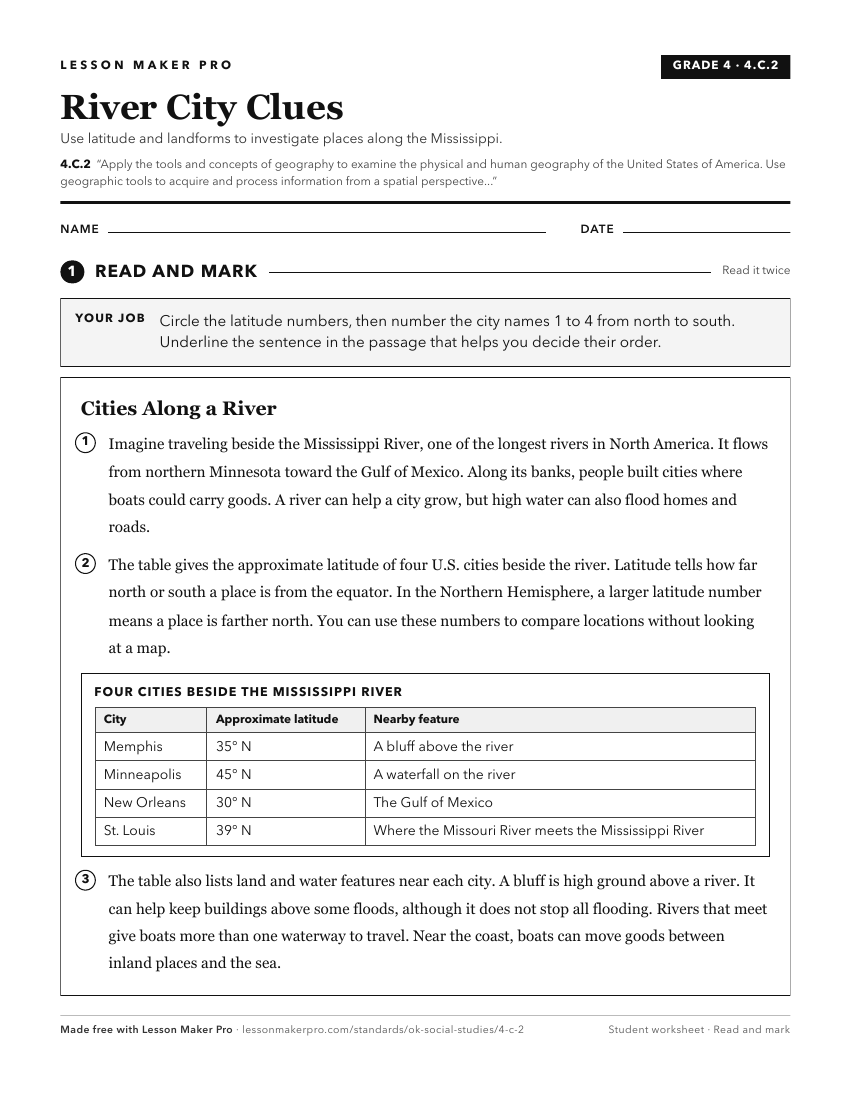
A ready-to-print activity worksheet aligned to 4.C.2, with an answer key for the teacher on its own page. No account needed.
PDF, US Letter, prints cleanly in black and white.
Download the worksheetKeep exploring
Related Standards
Turn this cluster into a lesson
Grade, subject, topic, and the complete cluster are prefilled. Create one free, no account needed.
Also for this cluster:Make a WorksheetMake a QuizMake a Sub Lesson