Oklahoma Social Studies 3.C.2
Standard Cluster
Examine Oklahoma’s geography and how people of Oklahoma interact with their environment. Use maps, graphs, photographs, charts, and geographic technology to organize information about people, places, and environments of the state. Examine Oklahoma’s political and physical features using physical and political maps. Explain the relative location of the student’s school and the state of Oklahoma to surrounding states and major physical regions of the United States of America. Distinguish between relative location and absolute location (latitude and longitude) to describe the location of Oklahoma’s major natural and human features on maps and globes. Interpret thematic maps of Oklahoma using essential map elements (e.g., title, legend, scale, compass rose) to examine geographic features of the state. Use both political and physical maps to identify Oklahoma’s major landforms, bodies of water, and major metropolitan centers, recognizing the Native origins of many place names. Describe the state’s climate and various natural vegetation zones, explaining how climate can affect natural vegetation and economic activities. Describe ways early inhabitants of present-day Oklahoma satisfied their basic needs and wants by interacting with the environment and using the natural resources of the region. Explain that people both adapt to and modify their environment in order to meet their basic needs and wants. Describe how the environment contains natural resources used by humans and identify the characteristics of renewable versus non-renewable resources by providing examples found in Oklahoma. Identify the ways in which physical geography influenced early American Indian cultures of the region (e.g., bison hunting, fur trading, farming). Describe how early settlers to the region adapted to and modified their environment (e.g., sod houses, windmills, irrigation of cash crops). Examine how Oklahomans continue to adapt and modify their environments to meet their needs. Summarize how weather events, such as floods and tornadoes, impact the people and economy of Oklahoma. Explain how Oklahomans changed their environments to support development of the state (e.g., recreational lakes, hydroelectric dams, wildlife refuges, the McClellan-Kerr Arkansas River Navigation System). Examine the concepts of scarcity and surplus of natural resources and describe the role of citizens in conserving the state’s resources (e.g., water rationing, recycling efforts).
Oklahoma Academic Standards for Social Studies (2026)
Cluster contents
Standards in This Cluster
3.C.2 is a cluster heading. These are the individual standards under it.
- 3.C.2.1
Use maps, graphs, photographs, charts, and geographic technology to organize information about people, places, and environments of the state.
- 3.C.2.2
Examine Oklahoma’s political and physical features using physical and political maps.
- 3.C.2.2.A
Explain the relative location of the student’s school and the state of Oklahoma to surrounding states and major physical regions of the United States of America...
- 3.C.2.2.B
Distinguish between relative location and absolute location (latitude and longitude) to describe the location of Oklahoma’s major natural and human features on ...
- 3.C.2.2.C
Interpret thematic maps of Oklahoma using essential map elements (e.g., title, legend, scale, compass rose) to examine geographic features of the state.
- 3.C.2.2.D
Use both political and physical maps to identify Oklahoma’s major landforms, bodies of water, and major metropolitan centers, recognizing the Native origins of ...
- 3.C.2.2.E
Describe the state’s climate and various natural vegetation zones, explaining how climate can affect natural vegetation and economic activities.
- 3.C.2.3
Describe ways early inhabitants of present-day Oklahoma satisfied their basic needs and wants by interacting with the environment and using the natural resource...
- 3.C.2.3.A
Explain that people both adapt to and modify their environment in order to meet their basic needs and wants.
- 3.C.2.3.B
Describe how the environment contains natural resources used by humans and identify the characteristics of renewable versus non-renewable resources by providing...
- 3.C.2.3.C
Identify the ways in which physical geography influenced early American Indian cultures of the region (e.g., bison hunting, fur trading, farming).
- 3.C.2.3.D
Describe how early settlers to the region adapted to and modified their environment (e.g., sod houses, windmills, irrigation of cash crops).
- 3.C.2.4
Examine how Oklahomans continue to adapt and modify their environments to meet their needs.
- 3.C.2.4.A
Summarize how weather events, such as floods and tornadoes, impact the people and economy of Oklahoma.
- 3.C.2.4.B
Explain how Oklahomans changed their environments to support development of the state (e.g., recreational lakes, hydroelectric dams, wildlife refuges, the McCle...
- 3.C.2.4.C
Examine the concepts of scarcity and surplus of natural resources and describe the role of citizens in conserving the state’s resources (e.g., water rationing, ...
Teacher's field guide
What This Cluster Means
What Students Need to Do
- Students locate Oklahoma and their school using maps, nearby states, and latitude and longitude. They compare landforms, cities, climate, plants, and place names with Native roots. They explain how Native peoples, settlers, and Oklahomans today use resources, change the land, and deal with severe weather.
What Mastery Looks Like
- Given physical, political, and climate maps, students locate Oklahoma City, the Arkansas River, and the Wichita Mountains using map keys. They explain how grasslands supported bison hunting and why settlers built sod houses. They can tell why rain can refill a river but oil cannot be replaced, and how floods affect people and jobs.
Common Misconceptions
- Students may confuse a location such as “north of Texas” with a latitude and longitude point. They may read colors on a rainfall map as state borders. Some think oil is renewable because Oklahoma has a lot of it, or that dams are natural features.
How to Assess It
- Give students an Oklahoma map with a legend, state borders, the Arkansas River, and Oklahoma City. Ask them to circle the river, name the state directly south, and describe one way people use or change the river.
Lesson moves
Ways to Teach It
Overlay a physical map with a political map; mark the Arkansas River, Wichita Mountains, Oklahoma City, and Texas on tracing paper.
Ask, “How did bison hunting meet food needs, and how did settlers’ sod houses meet shelter needs on Oklahoma grasslands?”
Use a gridded Oklahoma rainfall map for bingo; call a legend color, a compass direction, or a latitude-longitude point to find.
Show your town’s water-use notice; ask students whether limited rainfall could lead to rationing, and why conserving water helps.
Free download
Printable 3.C.2 Worksheet
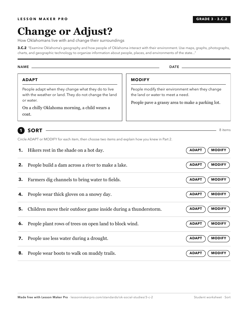
A ready-to-print activity worksheet aligned to 3.C.2, with an answer key for the teacher on its own page. No account needed.
PDF, US Letter, prints cleanly in black and white.
Download the worksheetKeep exploring
Related Standards
Turn this cluster into a lesson
Grade, subject, topic, and the complete cluster are prefilled. Create one free, no account needed.
Also for this cluster:Make a WorksheetMake a QuizMake a Sub Lesson